Where the week happened
Each numbered area is one of the stories below, drawn over the counties its warnings covered.
- Wildfire in California, Oct 15–16
- Severe storms in the Southern Plains, Oct 13–14
- Coastal flooding in North Carolina, Oct 16–18
- Flash flooding in Texas, Oklahoma and Kansas, Oct 14–15
- Tornadoes and severe storms in Texas and Oklahoma, Oct 14–15
The same areas as a list
- 1. Wildfire in California, October 15 to 16 · Heat and fire · 2 counties drawn
- 2. Severe storms in the Southern Plains and Texas, October 13 to 14 · Storms · 80 counties drawn
- 3. Coastal flooding in North Carolina, October 16 to 18 · Water · 2 counties drawn
- 4. Flash flooding in the Southern Plains and Texas, October 14 to 15 · Water · 68 counties drawn
- 5. Tornadoes and severe storms in Texas and Oklahoma, October 14 to 15 · Storms · 57 counties drawn
When it happened
- Fewer warnings
- More warnings
- Impact on people reported
View as a table
| Day | Warnings | Story on the map | Documented impact on people |
|---|---|---|---|
| Oct 12 | 344 | — | — |
| Oct 13 | 402 | 2 | Yes |
| Oct 14 | 791 | 2, 4, 5 | Yes |
| Oct 15 | 670 | 1, 4, 5 | Yes |
| Oct 16 | 686 | 1, 3 | Yes |
| Oct 17 | 500 | 3 | Yes |
| Oct 18 | 337 | 3 | Yes |
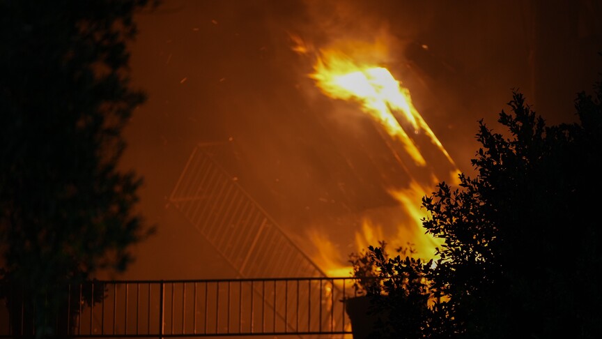
1Norte Fire damages homes and forces evacuations in Orange County
OCT 15, 8 PM UTC
County order
Los Angeles County, California
OCT 15, 9 PM UTC
County order
Los Angeles County, California
OCT 15, 9 PM UTC
County order
Los Angeles County, California
- Wildfire — coloured as heat and fire. 2 counties in California, Oct 15–16.
In San Juan Capistrano on October 16, Laura Hart described leaving home as the Norte Fire forced evacuations in Orange County, part of the California fire area marked 1 on the map. “This doesn’t usually happen to us, we usually see it on the news,” the evacuated resident told the Associated Press.
At least six homes were damaged or destroyed in the Norte Fire that day, SFGATE reported. By Friday night, about 16,000 residents had been ordered to evacuate, Orange County Fire Authority Chief TJ McGovern told the Associated Press. That count describes people ordered to leave, not a confirmed count of those who departed.
The Associated Press reported that two firefighters battling the Norte Fire were hospitalized with heat-related injuries on October 16. The disruption also reached classrooms: SFGATE reported that Capistrano Unified School District dismissed students early and canceled after-school programs. The City of San Clemente said it and San Juan Capistrano provided daytime reception for evacuees and worked with the American Red Cross to establish an overnight shelter at the Boys and Girls Club.
Separate fires had already prompted emergency messages in Los Angeles County on October 15. In Azusa, the Peak Fire brought evacuation orders before its order was reduced to a warning late that day, MyNewsLA reported. In Malibu, Los Angeles County's October 16 update reported minor injuries to Bryson Fire personnel, without a count, but no reported structure loss or damage. Those findings are separate from the Norte Fire's losses.
For the Norte Fire, officials reported no resident injuries as of October 16, according to Anadolu Agency. Orange County's final evacuation message announced: “OCSheriff: NORTE FIRE - All Evacuation Orders Lifted”. That ended the instruction to stay away, not the damage already documented in the community.
Wildfire alerts by the numbers: every published month, by state and county.
2Storms knock out power across Kansas City and injure a man in Carrollton
OCT 13, 9 PM UTC
First warning
McPherson County, Kansas
OCT 14, 6 AM UTC
Last warning
Blaine County, Oklahoma
- Severe storms — coloured as storms. 80 counties in the Southern Plains, Oct 13–14.
In Carrollton, Missouri, during the severe weather covered in KMMO's October 14 report, a tree limb crushed the top of a vehicle. Its occupant suffered moderate injuries and was taken to a hospital. The incident was part of the Plains and Missouri storm episode marked 2 on the map.
The warning sequence began in McPherson County, Kansas, on October 13, with a severe thunderstorm warning at 4:32 p.m. Other warnings named Kansas City, Liberty and Gladstone as places in the storms' path. Farther south, the weather service in Lubbock documented hail in Texas: “Quarter size hail was reported in Matador.”
People and animals outdoors will be injured. Expect hail damage to roofs, siding, windows, and vehicles. Expect wind damage to roofs, siding, and trees.
At the height of the October 13 storms, 62,000 Kansas City-area customers lost electricity, Evergy told Spectrum News. Fallen trees also blocked streets. Mark Huff, a Northland resident near Vivian and Antioch Road, told FOX4 Kansas City: “I saw the tree down, so I went and people were trying to get through and, I mean, it was completely blocked.”
A large tree fell onto power lines serving Chapel Hill Elementary and nearby residents overnight, Spectrum News reported. North Kansas City Schools canceled classes there on October 14 because of hazardous road conditions, according to FOX4. The station also reported downed trees and wires in Excelsior Springs, while another Kansas City home had limbs and water enter after a tree fell onto it.
By the morning of October 14, Evergy said electricity had been restored to more than 80 percent of affected customers, Spectrum News reported. Additional crews were arriving to help near Gladstone, Avondale and Liberty. Cleanup continued beyond the immediate outages: Spectrum reported that Gladstone offered free storm-debris drop-off through the end of October and Parkville offered free yard-waste drop-off.
Tornado alerts by the numbers: every published month, by state and county.
3Coastal storm cuts off Ocracoke and sends Hatteras visitors home
OCT 16, 10 PM UTC
County order
Dare County, North Carolina
OCT 17, 7 AM UTC
First warning
Dare County, North Carolina
OCT 17, 12 PM UTC
County order
Dare County, North Carolina
OCT 18, 12 PM UTC
County order
Dare County, North Carolina
- Coastal flooding — coloured as water. 2 counties in North Carolina, Oct 16–18.
Aboard the Ocracoke-to-Hatteras ferry on October 17, a wave smashed an SUV's windshield during the coastal storm affecting the Outer Banks, marked 3 on the map. Transportation officials told CBS 17 that its occupant was not injured. Passenger Megan Lawing told The News & Observer: “She was honking the horn, and you could see the water coming in through her windshield”.
The departure orders had begun the previous evening. Dare County ordered Hatteras Island visitors to evacuate beginning at 8 p.m. on October 16, excluding residents and areas north of Oregon Inlet. County emergency management's message read: “DARE COUNTY DECLARES STATE OF EMERGENCY - HATTERAS ISLAND VISITORS ORDERED TO EVACUATE”.
For the Beach Hazards Statement, dangerous rip currents, large breaking waves expected, and strong longshore currents in the surf zone. For the High Surf Advisory, large breaking waves of 8 to 14 feet expected in the surf zone. For the…
A coastal flood warning followed early on October 17, and Dare County repeated its evacuation message that morning. After the ferry docked that day, its crew reported the windshield incident to the sheriff's office and secured a tarp over the SUV, CBS 17 reported. By October 18, the county said the visitor evacuation remained mandatory and visitors were prohibited from entering Hatteras Island.
Ocracoke was inaccessible on October 18 because all ferry services were suspended, the National Park Service reported. Cape Hatteras National Seashore campgrounds, off-road vehicle routes and lighthouse climbing also remained closed because of hazardous conditions.
On October 18, Dare County reported that soundside flooding had begun in Hatteras Village and crews were clearing wind-blown sand and addressing dune erosion. Island Free Press reported minor to moderate ocean overwash on northern Rodanthe side roads during the afternoon high tide, but N.C. Highway 12 remained open and passable. Across the official updates and news reports checked for this coastal storm, no deaths or injuries were reported.
Flood alerts by the numbers: every published month, by state and county.
4Floodwater strands an SUV near El Reno and closes a Texas road
OCT 14, 2 AM UTC
First warning
Harper County, Kansas
OCT 14, 11 AM UTC
Considerable threat
Canadian County, Oklahoma
OCT 15, 8 PM UTC
County order
Lubbock County, Texas
OCT 19, 12 AM UTC
Last warning
Canadian County, Oklahoma
- Flash flooding — coloured as water. 68 counties in Texas, Oklahoma and Kansas, Oct 14–15.
On Banner Road between Yukon and El Reno on October 15, an SUV became stranded in floodwater and crews responded to a reported water rescue, Hoodline reported, citing KOCO. The scene falls within the Southern Plains flooding area marked 4 on the map. The account does not establish whether anyone was rescued or describe the occupants' eventual condition.
The warning sequence had begun in Harper County, Kansas, on the evening of October 13. By the following morning, a Canadian County flash flood warning carried a considerable damage designation. Flooding also reached Norman on October 14, where storm chaser Nick Smith described it to KOCO as “one of the worst times I've seen it flood”.
Near Bridgeport on October 15, the weather service in Norman reported major flooding on the Canadian River. That afternoon in Lubbock County, the Texas Department of Transportation issued a direct instruction to drivers: “FM 835 CLOSED DUE TO FLOODING SEEK ALTERNATE ROUTE”. The closure was documented in the department's emergency alert reproduced by GovOneStop.
Flood warnings in Canadian County continued into October 18. The documented accounts show a stranded vehicle, a response to a reported rescue and a road closure, but not a confirmed rescue outcome. Across the official bulletins and news reports checked for this flooding, no deaths or injuries were reported.
Flood alerts by the numbers: every published month, by state and county.
5Tornadoes tear metal from buildings in and near Fort Stockton
OCT 14, 6 PM UTC
First warning
Dickens County, Texas
OCT 14, 7 PM UTC
Tornado seen
Pecos County, Texas
OCT 15, 5 AM UTC
Last warning
Creek County, Oklahoma
- Tornadoes and severe storms — coloured as storms. 57 counties in Texas and Oklahoma, Oct 14–15.
Near the Pecos County courthouse and James Rooney Memorial Park in Fort Stockton on October 14, a tornado peeled away metal roofing and broke large tree branches. The weather service's preliminary damage survey documented the damage the next day. Fort Stockton lies within the Texas and Oklahoma storm area marked 5 on the map.
The afternoon's warning sequence began with a severe thunderstorm warning in Dickens County. By 2:30 p.m. on October 14, a tornado warning in Pecos County identified an observed tornado, rather than only a radar indication. A subsequent weather service message confirmed a tornado northeast of Fort Stockton moving northeast.
At 236 PM CDT, a confirmed tornado was located 7 miles northeast of Fort Stockton, moving northeast at 20 mph.
The preliminary survey documented another tornado northeast of Fort Stockton that removed metal wall panels from a building and damaged mesquite trees while crossing open fields. Elsewhere that afternoon, a storm chaser reported sheet metal blown from barns north of Harrold, according to a weather service local storm report.
Severe storms continued into Oklahoma that night. The weather service in Norman warned: “Expect considerable tree damage. Damage is likely to mobile homes, roofs, and outbuildings.” That was a forecast of possible impacts, distinct from the damage survey already being assembled around Fort Stockton.
On October 15, the weather service's preliminary survey rated the Fort Stockton tornadoes EF0 and EF1 and reported no fatalities or injuries from either. The broader review of official reports and news coverage likewise found no deaths or injuries reported for this storm episode. The documented cost in Fort Stockton was damage to roofing, building panels and trees.
Tornado alerts by the numbers: every published month, by state and county.
How BePrepared monitors this, all year
This report exists because we already monitor the whole country. Every couple of minutes, around the clock, we read the emergency alerts going out across all fifty states and territories, and we keep them. A month of that record is what you have just read.
The national picture is the part most people never see. What matters to you is much smaller: which of these warnings would have reached your street, and what the risks around you look like on an ordinary day.
That is what BePrepared is for. Put in your ZIP code and you get the picture for where you live — the flood, fire and storm history around you, the dams and facilities nearby, and a plan for your household rather than a general one. With a free account you can keep a watchlist of the places you care about, like your home, your parents' address, and your kids' school, and set what you want to hear about.
Where it hit hardest
Counted as distinct warnings, and as the days a county spent under one. A county is the smallest area these warnings describe.
Warnings by region
- Texas136
- Southern Plains115
- Mid-Atlantic27
- Midwest24
- Southwest20
Most days under a warning
- Brantley County, GA8 days
- Lake County, FL8 days
- Volusia County, FL8 days
- Calcasieu Parish, LA7 days
- Sarasota County, FL7 days
- Brewster County, TX6 days
- Canadian County, OK6 days
- Cleveland County, OK6 days
Where the warnings landed
- Winter
- Flooding
- Severe storms
- Everything else
Winter4,350 warnings · 1,069 counties
Flooding2,463 warnings · 435 counties
Severe storms1,966 warnings · 352 counties
Fire1,171 warnings · 192 counties
Safety & civil153 warnings · 65 counties
Tornadoes35 warnings · 13 counties
View as a table
| County | State | Warnings | Most frequent kind |
|---|---|---|---|
| Canadian | OK | 86 | Flooding |
| Cleveland | OK | 77 | Flooding |
| McClain | OK | 71 | Flooding |
| Caddo | OK | 69 | Flooding |
| Tillman | OK | 62 | Flooding |
| Wilbarger | TX | 62 | Flooding |
| Dickens | TX | 60 | Severe storms |
| Grady | OK | 59 | Flooding |
| Brewster | TX | 59 | Flooding |
| Oklahoma | OK | 48 | Flooding |
| Foard | TX | 48 | Severe storms |
| Pottawatomie | OK | 48 | Flooding |
| Pecos | TX | 47 | Severe storms |
| Kiowa | OK | 46 | Flooding |
| Hardeman | TX | 46 | Severe storms |
| Jackson | OK | 45 | Flooding |
| King | TX | 45 | Severe storms |
| Wichita | TX | 45 | Flooding |
| Collingsworth | TX | 44 | Flooding |
| Washita | OK | 43 | Flooding |
The human record
What it cost, and who reported it
These figures are not ours. Our archive records that a warning was issued, never what happened next, so every number here comes from the organization named beside it and was retrieved on October 20, 2026.
Toll
570acres burned
The Norte Fire had burned 570 acres in Orange County by the evening of October 16, 2026.
Source: SFGATE
ArchiveOur records show wildfire warnings covering this area on October 16.
Toll
2firefighters hospitalized
Two firefighters battling the Norte Fire were hospitalized with heat-related injuries on October 16.
Source: Associated Press
Toll
Officials reported no resident injuries from the Norte Fire as of October 16.
Source: Anadolu Agency
Toll
146acres burned
The Bryson Fire in Malibu had burned 146 acres by October 16.
Source: County of Los Angeles
Toll
Los Angeles County reported minor injuries to Bryson Fire personnel without specifying how many people were injured.
Source: County of Los Angeles
Toll
1person injured
KMMO reported that one man in Carrollton, Missouri, suffered moderate injuries during the severe weather when a tree limb crushed the top of his vehicle, and he was taken to a hospital.
Source: KMMO
ArchiveOur records place this event in Missouri between 2026-10-13 and 2026-10-14.
In their words
Kansas City resident Mark Huff told FOX4 that storm winds broke part of his decades-old oak tree near Vivian and Antioch Road and that the fallen tree blocked passage.
“I saw the tree down, so I went and people were trying to get through and, I mean, it was completely blocked.”
Mark Huff, Kansas City Northland resident near Vivian and Antioch Road, to FOX4 Kansas City Damage
A large tree fell onto power lines, cutting electricity overnight to Chapel Hill Elementary and nearby residents.
Source: Spectrum News
Damage
FOX4 reported that a tree fell onto another Kansas City home, allowing water and limbs inside, and the homeowner said nobody there was hurt.
Damage
FOX4 reported downed trees and wires on the Ray County side of Excelsior Springs, along with downed wires, tree limbs and a snapped streetlight pole in Clay County.
Toll
NCDOT officials told CBS 17 that the woman whose SUV windshield was smashed by a wave aboard the Ocracoke-to-Hatteras ferry on October 17 was not injured.
Source: CBS 17 / WNCN, syndicated by AOL
In their words
Passenger Megan Lawing told The News & Observer that water entered a neighboring vehicle through its damaged windshield during the October 17 ferry crossing from Ocracoke to Hatteras.
“She was honking the horn, and you could see the water coming in through her windshield”
Megan Lawing, Passenger on the October 17 Ocracoke-to-Hatteras ferry, to The News & Observer Damage
1vehicle with a smashed windshield
NCDOT confirmed that a wave smashed a vehicle's windshield aboard the ferry during the October 17 crossing.
“A vehicle was parked in the front of the deck. A wave came over and hit and smashed the vehicle’s windshield”
Jamie Kritzer, North Carolina Department of Transportation assistant director of communications, to CBS 17 Source: CBS 17 / WNCN, syndicated by AOL
Damage
Dare County reported that soundside flooding had begun in Hatteras Village during the coastal storm.
Source: Dare County Government
Damage
Island Free Press reported minor to moderate ocean overwash on northern Rodanthe side roads during the October 18 afternoon high tide, while N.C. Highway 12 remained open and passable.
Source: Island Free Press
Rescue
Crews responded to a reported water rescue on October 15 after an SUV became stranded in floodwater on Banner Road near State Highway 66 between Yukon and El Reno.
Source: Hoodline, citing KOCO
In their words
Nick Smith described flooding in Norman.
“one of the worst times I've seen it flood”
Nick Smith, First Alert Storm Chaser, to KOCO Source: KOCO
Damage
The National Weather Service reported major flooding occurring on the Canadian River near Bridgeport on October 15, with its warning covering Blaine, Caddo, Canadian and Grady counties.
Source: National Weather Service Norman, bulletin reproduced by Defcon Level
Closed
An October 15 Texas Department of Transportation emergency alert stated that FM 835 was closed because of flooding and instructed motorists to seek an alternate route.
Source: Texas Department of Transportation, alert reproduced by GovOneStop
ArchiveOur records show flash flooding warnings covering this area on October 15.
Response
On October 14, the National Weather Service issued a flood warning for the Canadian River near Mustang affecting Canadian, Cleveland, McClain and Grady counties, forecasting minor flooding from late that night through October 16.
Source: National Weather Service Norman, bulletin reproduced by iAlert
Toll
0 deaths and 0 injuries for each tornado
The National Weather Service's preliminary survey reported zero fatalities and zero injuries for each of the two October 14 tornadoes in and near Fort Stockton, Pecos County.
Source: National Weather Service Midland/Odessa, archived by Iowa Environmental Mesonet
ArchiveOur records show tornadoes and severe storms warnings covering this area on October 14.
Damage
The first Fort Stockton tornado peeled off metal roofing and broke multiple large tree branches near the Pecos County courthouse and James Rooney Memorial Park.
Source: National Weather Service Midland/Odessa, archived by Iowa Environmental Mesonet
Damage
The second tornado northeast of Fort Stockton removed metal wall panels from a metal building and damaged mesquite trees as it crossed open fields.
Source: National Weather Service Midland/Odessa, archived by Iowa Environmental Mesonet
Damage
A storm chaser reported sheet metal blown off barns five miles north of Harrold in Wilbarger County at 5:35 p.m. CDT on October 14.
Source: National Weather Service Norman
ArchiveOur records show tornadoes and severe storms warnings covering this area on October 14.
Response
The National Weather Service conducted a damage survey in and near Fort Stockton on October 15 and identified two tornadoes, rated EF0 and EF1.
Source: National Weather Service Midland/Odessa, archived by Iowa Environmental Mesonet
For 3 of these stories, research looked for reported deaths and injuries and found none. As far as the record shows, no one was hurt.
The numbers behind this report
Every warning counted once, by type, place, day and hour, with the method below and the whole table downloadable at the end of the page.
What was warned about
| Alert type | Warnings | Messages |
|---|---|---|
| Severe Thunderstorm Warning | 555 | 555 |
| Small Craft Advisory | 534 | 3,085 |
| Special Weather Statement | 291 | 293 |
| Flood Advisory | 253 | 254 |
| Flood Warning | 223 | 257 |
| Wind Advisory | 187 | 425 |
| Freeze Warning | 185 | 332 |
| Gale Warning | 171 | 1,255 |
Where
| State | Warnings |
|---|---|
| TX | 539 |
| OK | 392 |
| KS | 167 |
| CA | 153 |
| FL | 112 |
| AK | 81 |
| PA | 77 |
| CO | 71 |
The busiest hour of the period was 6pm local time, with 299 warnings.
Counties reached most often
| County | State | Warnings |
|---|---|---|
| Canadian | OK | 86 |
| Cleveland | OK | 77 |
| McClain | OK | 71 |
| Caddo | OK | 69 |
| Tillman | OK | 62 |
| Wilbarger | TX | 62 |
| Dickens | TX | 60 |
| Grady | OK | 59 |
| Brewster | TX | 59 |
| Oklahoma | OK | 48 |
A county with no alerts is not a county with no risk. It can mean a quiet period, or a hazard that this feed does not carry.
When the warnings arrived
View as a table
| Local hour | Warnings | Of which most severe |
|---|---|---|
| 12am | 109 | 1 |
| 1am | 127 | 0 |
| 2am | 164 | 2 |
| 3am | 105 | 2 |
| 4am | 98 | 0 |
| 5am | 105 | 2 |
| 6am | 120 | 0 |
| 7am | 97 | 0 |
| 8am | 173 | 1 |
| 9am | 132 | 2 |
| 10am | 124 | 1 |
| 11am | 142 | 1 |
| 12pm | 151 | 5 |
| 1pm | 185 | 4 |
| 2pm | 192 | 8 |
| 3pm | 142 | 5 |
| 4pm | 150 | 5 |
| 5pm | 230 | 12 |
| 6pm | 299 | 15 |
| 7pm | 222 | 14 |
| 8pm | 213 | 7 |
| 9pm | 174 | 4 |
| 10pm | 119 | 1 |
| 11pm | 157 | 1 |
The feed repeats itself
View as a table
| Stage | Count |
|---|---|
| Messages received | 9,079 |
| Of which updates | 5,506 |
| Of which cancels | 0 |
| Distinct warnings | 3,730 |
| Counties reached | 3,078 |
How severe they were
- Minor
- Moderate
- Severe
- Extreme
- Not classified
View as a table
| Severity | Warnings |
|---|---|
| Minor | 1,054 |
| Moderate | 969 |
| Severe | 1,599 |
| Extreme | 93 |
| Not classified | 15 |
What people were told to do
- Avoid
- Follow instructions
- Shelter
- Everything else
Where those instructions came from
- Shelter (591) — 192 corroborated as flood, 50 corroborated as tornado, 349 with no hazard stated in the alert text
- Evacuate (7) — 2 corroborated as flood, 4 corroborated as wildfire, 1 with no hazard stated in the alert text
View as a table
| Response | Warnings | Share |
|---|---|---|
| Avoid | 1,491 | 40.0% |
| Follow instructions | 845 | 22.7% |
| Shelter | 591 | 15.8% |
| Prepare | 547 | 14.7% |
| Monitor | 203 | 5.4% |
| Unstated | 39 | 1.0% |
| All clear | 7 | 0.2% |
| Evacuate | 7 | 0.2% |
What this report cannot tell you
- This report records the warnings that were sent: when, where, and what people were told to do. It cannot say whether anyone received them, whether they acted, or whether they had anywhere to go.
- Deaths, injuries, damage and acreage come from the news organizations and agencies named beside each figure. Our own records measure warnings, never outcomes, and are never the source for a toll.
- A county is the smallest area these alerts describe, so "a county was warned" does not mean every street in it was at risk.
- Where no figure has been reported, this report says so rather than estimating.
How these numbers were counted
Counted OCT 12, 2026 – OCT 19, 2026 · Frozen at publishThe alert figures in this report — how many warnings, where, when, and how severe — come from the alerts this archive received from FEMA IPAWS and the National Weather Service between October 12, 2026 and October 19, 2026, counted once and frozen when the report was published.
Deaths, damage and acreage are not ours and are never drawn from this archive. Each is attributed to the organization that reported it, above.
What was counted
- cap_status = 'Actual' (tests, exercises and demos excluded)
- SAME test codes RWT/RMT/DMO/NPT/NAT excluded, and any event type containing "test"
- An event is the first message of a CAP identifier chain; updates and cancels are counted separately
- Alert time is cap_sent, falling back to ingest time when the feed omits it
- Counties come from the alert geocodes (SAME/FIPS); statewide codes are not counted as counties
What these numbers cannot tell you
- Lead time is the gap between when an alert was sent and when it takes effect. This archive collapses CAP onset into effective, so for many products those are the same instant by design — it is not a measure of forecast warning time.
- 20 alerts expire exactly 24 hours after they were sent because the feed omitted an expiry and the ingest substitutes a default. They are excluded from the duration distribution rather than charted as real forecasts.
- Evacuation and shelter figures are RESPONSE counts. They record what people were told to do, not what caused it; where the alert text does not name a hazard, the row is reported as unstated.
- Hour-of-day figures use each alert’s own local time, resolved from its state. Alerts spanning several states resolve to the first state in their geocodes.
- National Weather Service alerts began arriving in volume on 2026-06-12. Earlier months hold only the handful that reached this archive by other routes, so they undercount weather alerts badly and cannot be compared with later months.
- Population figures are not available for these counties, so alert counts are reported per county and never per resident.
This archive
Collection began 2026-03-27. National Weather Service alerts began arriving in volume on 2026-06-12 (a small number reached the archive by other routes from 2026-03-31). Months from 2026-07-01 onward can be compared with each other; earlier ones cannot.
Photographs
The photos come from the reporting each story cites, or from public-domain and openly licensed collections. Each is credited as published and links to the page it came from; none belongs to BePrepared, and each is shown uncropped. To ask for a photo to be removed, write to support@bepreparedsolutions.co.
For newsrooms and researchers
Use these figures
Journalists, emergency managers and researchers are welcome to reuse anything in this report, including the underlying counts, with attribution. Version 1 of these figures is frozen: if a correction changes them, it appears above as a dated note rather than silently replacing what you cited.
BePreparedSolutions.co. "Fires damage Orange County homes as storms hit the Plains and Outer Banks." Alert Pulse, October 20, 2026. https://bepreparedsolutions.co/reports/alert-pulse/week-2026-10-12
Source: BePrepared Solutions, Alert Pulse (2026). Alert counts from FEMA IPAWS and National Weather Service feeds; casualty and damage figures as attributed in the report.
<iframe src="https://bepreparedsolutions.co/reports/alert-pulse/week-2026-10-12/embed/reach_map" width="100%" height="520" style="border:0" loading="lazy" title="Fires damage Orange County homes as storms hit the Plains and Outer Banks"></iframe>
The embed updates itself if we publish a correction, so it never goes stale the way a screenshot does.
The CSV carries the same frozen figures as this page, keyed to version 1.